
Story: TRUONG QUY
Photos: AMACHAU
We follow the Red River as it runs through Vietnam’s capital
The Red River was formerly known as the Cai River, which is synonymous with the “Mother River”. The flow of this river has shaped both the landscape and name of the city of Hanoi. For this reason, since time immemorial, the river has always been a source of yearning and love for generations of Hanoians.

The name “Red River” might have only become popular after the French started to call it “Fleuve Rouge” on account of its color. This was to distinguish it from the Da River, known as the “Black River” (Rivière Noire), and the Lo River, then called the “Clear River” (Rivière Claire) – both of which are the primary tributaries of the Red River. The part that runs through Hanoi lies in the middle of a delta nourished by its silt-laden water, making it the most prosperous settlement in the thousand-year-old heartland of Vietnam. The most prominent cultural characteristics and features of Northern Vietnam are linked to the 163-km-long river that runs through Hanoi’s quarters and districts.

Flowing past ancient sites
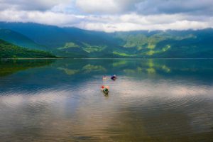
The Red River begins to flow into the outskirts of Hanoi from Trung Hà Confluence, where the serpentine Da River joins the stream. West of Thang Long Imperial City, this area was known as Son Tay Town, also called Doai Town, the heartland of Vietnamese people for millennia. The Red River runs through the regions of Ba Vi and Son Tay, meandering around Tan Vien Mount – home to a Vietnamese mountain spirit – to create an evocative shan shui landscape. Dotted along the river banks are communal temples that made the region famous, as evidenced by the saying: “Southern bridges, Northern pagodas, and Doai’s communal temples.” Communal temples designated national heritages such as Tay Dang, Chu Quyen, and Thuy Phieu were built 500 years ago. The Doai Communal Temple, where villagers used to gather, features prominent structural elements of stilt huts from the semi-highland regions, with giant ironwood pillars and a raised floor to avoid flooding and insects. Its unique beam system supports a vast gabled roof with characteristic eaves that arch upwards to resemble the bow of a sailing ship on the river. Set beneath a red cotton tree, the communal temple is a focal point beside the Mother River, with its somber brown hues offset by the lush greenery of the nearby dyke.

Downstream on opposite banks lie the regions of Phuc Tho and Me Linh, where the Trung Sisters rebelled against the Western Han Dynasty. The northern bank is part of Me Linh District, the home of the sisters, while the southern bank hosts the Hat Mon Ruins, where they took their lives after losing the war. The ancient temple is located on the Hat River, a confluence where the Day River meets the Red River. It is said that the sisters turned into two statues that floated down the Cai River to Dong Nhan Village, south of Dai La Region – the downtown area of modern-day Hanoi. The locals collected the statues and built a shrine by the riverside before building a larger temple on higher ground in Huong Vien Village. This is one of the most important landmarks in Hanoi. In addition, the central southern district of Hanoi, located directly opposite the Red River, is called the Hai Ba Trung District.
The central districts of Hanoi began with Tu Liem, the Sino-Vietnamese name for the ancient locale Chem. Located on the shore of Chem and facing the river is the Temple of Ly Ong Trong, a legendary general born two thousand years ago. The communal temple of Chem is popular for its imposing and impressive architecture, with ancient brick walls and precious artifacts dating back to the Later Le Dynasty. Right next to the Chem communal temple lies the village of Dong Ngac, also known as Ke Ve, associated with local scholars who became powerful magistrates. Aside from the Ve communal temple, Dong Ngac Village also preserves many old traditional Vietnamese houses as well as Franco-Vietnamese villas.
A city nourished by silt
The Chem and Dong Ngac areas have long drawn young people thanks to the bamboo groves at the foot of the dyke, from where you can admire various bridges, including Thang Long Bridge and Nhat Tan Bridge, which are representative of two periods of Hanoi’s development in the 1980s and 2010s.

Here, the Red River twisted and turned to create West Lake and the floodplains formed by its main northwest-southeast stream. This area is known for its craft villages that specialized in shrubs and flowers, including Nhat Tan peach blossoms, Tu Lien kumquat trees, and Quang Ba flowers. Nowadays, while arable land for flower-growing has shrunk, these floodplains remain home to entertainment parks where iconic Tet flowers are grown and young people like to wander about. Green spaces like Red River Stone Garden and the area beneath Long Bien Bridge enliven Hanoi’s scenery and are often used as backdrops for films. The Red River’s left bank, including Long Bien Longan Garden at the foot of Vinh Tuy Bridge and Bac Cau Peninsula, where the Duong River meets the Red River, are popular camping spots for Hanoians. People gather here to watch the sun set over the city center’s skyline of dense high-rises.
Though new bridges have been built, with its timeworn 200-year-old iron beams, Long Bien Bridge continues to draw tourists who wish to stroll and take pictures. The station at the start of the bridge is no longer just a train station but a popular tourist destination. The quaint sepia look of the old town beneath the stone arches ties the Red River and the bridge to the rest of the city.
Flowing into the future
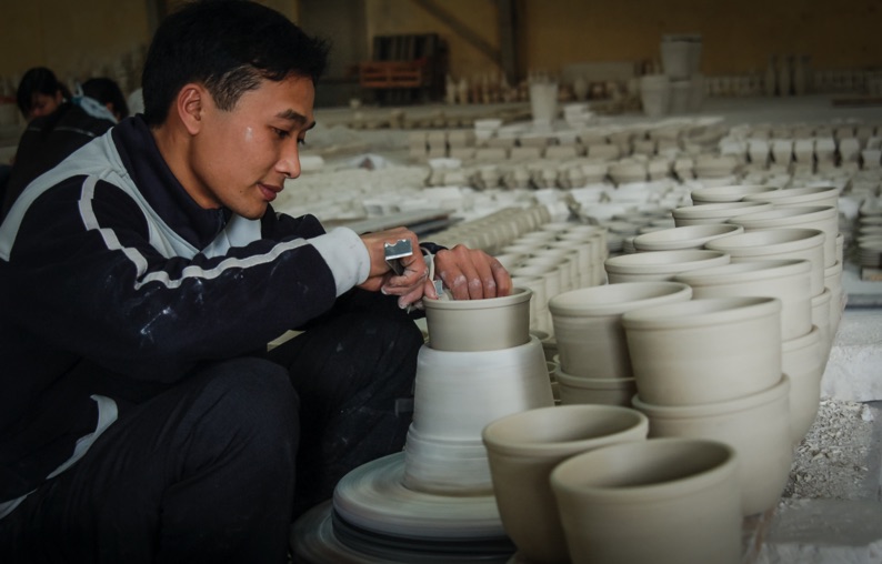
After following a rather straight course through the city, the Red River starts to bend in the Thanh Tri District. Situated along this bend are ferry ports and popular artisanal villages, including the world-famous Bat Trang Village and its market. Located 13 kilometers from Hanoi, Bat Trang exports its prize products from its homeport. Further down the river are landmarks from the Tales of Chu Dong Tu, and famous battlefields from the Yuan Campaigns, such as Chuong Duong and Ham Tu. As the wind blows, wanderers are often reminded of the poetic verses written by Prince Tran Quang Khai upon his return to Thang Long Imperial City: In peace, strive for greatness; Thy Land shall outlast the sun.

Along the riverbanks are affluent villages connected by winding paths that are perfect biking trails for those with enough passion and stamina. These villages’ riverside temples and pagodas combine with the river banks to create a system of public spaces, forming a different aspect of the city that is free and full of potential. It is time for the city to awaken this new potential and return to its roots along the rivers that shaped its entire being. Many Hanoians dream of daily commutes on river ferries and of walking and biking trails that connect the city’s green riverside spaces.


