Nguyen Hai
Giang Man is a mountain range between the buffer zones of Vu Quang National Park (Ha Tinh province) and Phong Nha-Ke Bang National Park (Quang Binh province). This majestic range is part of the Truong Son mountain system, which extends into Laos. Some towering peaks are perpetually shrouded in clouds, including Phi Co Pi Peak (2,071m). The highest mountain in Quang Binh province, Phi Co is famously known as the “guardian of the mountains”.

The Giang Man range occupies most of Minh Hoa and Bo Trach districts, which are hard to access. I had to rely on officers from the Ra Mai border outpost in Trong Hoa commune, Minh Hoa district to reach this region. After traveling over 150 kilometers from Dong Hoi city, I arrived at the border outpost, to be met by kind and friendly officers, fresh air, and melodious birdsong. The worries of city life felt far away in the forest, leaving me excited to explore the natural environment and the lives of the local ethnic minority people.
Early the next morning, under clear skies, I gazed down at the distant mountains, where peaks have embraced the clouds for ages. If I’d known the way, I’d have left the outpost at the crack of dawn. The officers seemed to understand my mood as I meticulously prepared my photography equipment and gear. They served me a hurried bowl of rice before we set off to visit nearby villages of ethnic Khua and May people.

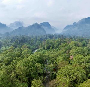
Along the road, I was captivated by clouds and mountains. The clouds resembled curtains draped over overlapping layers of mountains. My officer guides mentioned that an extensive subterranean river system stretches for dozens of kilometers beneath these limestone mountains. These underground rivers extend into Phong Nha-Ke Bang National Park.
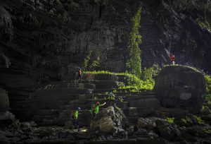
One side of the road was flanked by towering limestone cliffs, while the other dropped to abyssal depths with sharp bends that made my heart race. After 30 minutes by motorbike on the narrow access road to the villages, we stopped at Cha Cáp village, the highest among the four villages on this route. From this safe vantage point, I comfortably took photos, capturing images of cloud-wrapped mountains and peaks peeking through thin veils of mist. The mountains and clouds seemed to touch my soul, presenting a pure gift from nature. From this high point, looking down into the distance, I could see La Trong Hydroelectric Plant. Nestled between the mountain cliffs the reservoir appeared like a “hanging lake” in the majestic wilderness. This hydroelectric reservoir collects water from local creeks and streams. The pristine forests around this lake are strictly protected by the government and local communities.

At the far end of the reservoir is the confluence of Doi and Do creeks. We followed the riverbank to Do-Ta Vong village to learn about the lives of the local inhabitants. In 2019, Minh Hoa district chose to develop this village into a “New Rural Area for Ethnic Minority Communities”. The scattered houses along the mountainside were consolidated into a single village of approximately 100 households. Previously, the villagers depended on the forest and cultivated corn in rocky crevices as their main food source. Government planning, the construction of schools and service stations, and especially guidance on terraced rice cultivation and livestock investment have made the villagers’ lives easier and more stable.
This peaceful village is adorned with lush green corn and rice paddies. The villagers live harmoniously with nature and believe that a deity guards each peak in the Giang Man range. To thank these protective spirits, they organize annual thanksgiving ceremonies such as mountain worship, new rice offerings, and wrist-tying rituals. Khua and May people believe that spiritual bonds tie the soul and the body together. A spiritual cord is worn around the wrist, serving as a talisman that protects the wearer and brings health and fortune.
Villagers in Do-Ta Vong invited me to return in the spring to witness countless spring flowers and participate in the wrist-tying ceremony to pray for blessings and luck.
I bid farewell to the rugged, steep slopes. The verdant, cloud-covered mountains stand day after day, with villages nestled along the mountainsides. The gentle faces of the border soldiers and local people remain etched in my memories of my peaceful time in Giang Man.


