Story: Nam Hoa
Photos: Quang Ngoc, Ba Ngoc
Vietnam boasts over 3,200 kilometers of coastline, and defining maritime territorial boundaries, of which the foundational element is the system of basepoints established by the Government of the Socialist Republic of Vietnam in its Declaration on the Baseline dated November 12, 1982, crucial for both economic development and national security and defense. The baseline traces the contour of Vietnam’s coastline. According to the 1982 Declaration, as supplemented on February 21, 2025, Point 0 is a notional point at sea located on the straight line connecting Hon Nhan Island (Vietnam) and Wai Island (Cambodia). Of all the designated points, only Point A8 lies on the mainland, in Phu Yen; the rest are located on offshore islands.
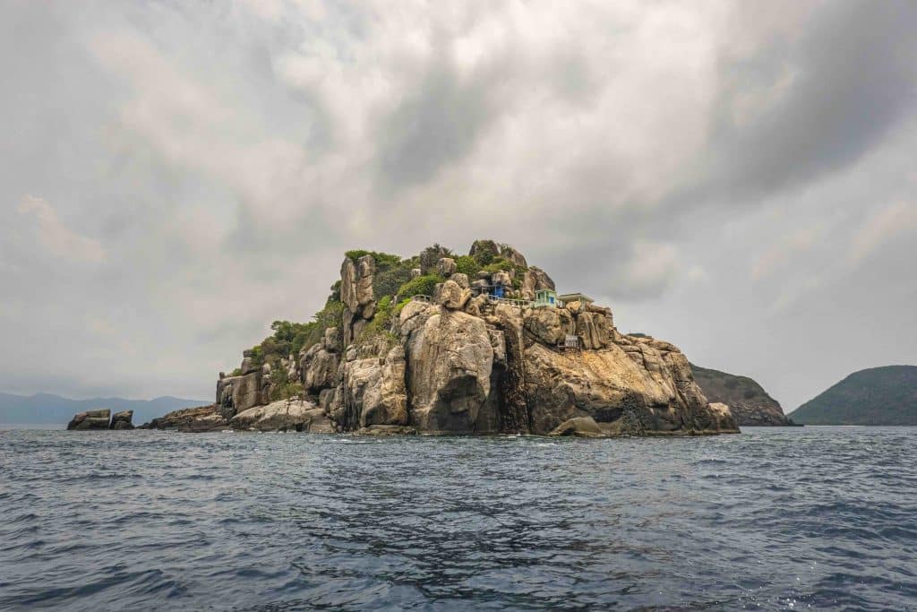
Among these basepoints, A6 is the most exceptional. Positioned at the midpoint of the baseline, it is the highest and southernmost of all the points in the East Sea. It sits at an elevation of approximately 113 meters atop Hon Hai (Binh Thuan), a massive rock formation shaped like a whale breaching the ocean’s surface. The journey to reach Point A6 is also the most arduous, as Hon Hai is the most remote of the basepoints, farthest from any inhabited area. Travelers must endure 12 hours at sea from Phu Quy Island. Only after seeing Hon Hai loom like a fortress at dawn, using a crane to ascend the island (as vessels cannot dock), and climbing through a concrete tunnel carved into this colossal rock to reach Point A6 as passing flocks of startled seabirds scatter skyward, can the profound sanctity of Vietnam’s maritime sovereignty truly be felt.
Points A1 and A2 are situated on small islands whose jagged, rocky shores pose significant challenges for boat access. A1 is set on Hon Nhan (Kien Giang), more than 5 kilometers from the main island in the Tho Chu archipelago. Its geographic remoteness from the mainland is comparable to that of Point A6. Although very few ferry routes connect the mainland to Tho Chu, Point A1 has still welcomed many groups of visitors due to its proximity to the island. Point A2 marks the southernmost point of the baseline. It is located on Hon Da Le (Ca Mau), roughly 7 kilometers from the military outpost of Hon Khoai. Hon Da Le is a solitary black rock formation, over 100 meters long and about 30 meters wide at its broadest point, rising approximately 7 meters above sea level. Reaching it requires support from military vessels, and even then, visitors must depart the island swiftly depending on wave and wind conditions.
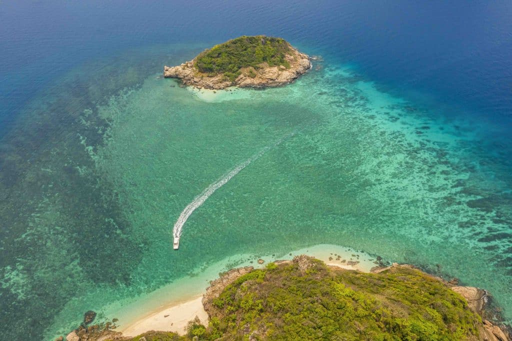
The three points of A3, A4, and A5 are clustered low in the southeastern East Sea, concentrated across islands within the Con Dao archipelago (Ba Ria – Vung Tau). Point A3 is located on Hon Tai Lon, the largest island of the group east of the main Con Son island, about 2 kilometers from Ca Map Cape. It stands on a relatively low rocky ledge on the island’s eastern side, with stone steps leading up from the water’s edge to Point A3.
Point A4 is set halfway up a cliffside near the residence of the rangers guarding birds’ nests in Con Dao National Park. It lies on the southern side of Hon Bong Lan, a roughly square-shaped rocky island with sides just over 150 meters in length, about 5.5 kilometers from Hon Tai Lon and close to the southern tip of Hon Bay Canh.
Point A5 is isolated on the eastern side of Hon Bay Canh, the second largest island in the archipelago. Positioned roughly 20 meters above sea level on a steep cliff, it lies beneath the island’s lighthouse. Although Hon Bay Canh is popular for tourism and exploration activities, accessing Point A5, whether overland or by sea, remains a challenge due to steep cliffs. Still, points A3, A4, and A5 are located in a tourist-accessible area and can be viewed from sightseeing boats departing from Con Son Island.
Among all the offshore points, A7 on Hon Doi (Khanh Hoa) is closest to the mainland, lying around 1 kilometer from Mui Doi, the easternmost point of mainland Vietnam. However, due to strict management by a designated unit, tourists are not permitted to land on the island and must instead admire Hon Doi and Point A7 from Mui Doi. Those who are unable to complete the 12-kilometer trek across sand dunes and rugged rocks to Mui Doi may hire a fishing boat from Hon Gom Peninsula to observe the island and Point A7 from offshore.
A8 is the only point located on the mainland, at Dai Lanh Cape (Phu Yen). From the base of Dai Lanh Lighthouse, a stone staircase leads down toward the sea, where point A8 is placed near the lighthouse’s information board. It is one of the most accessible base points, situated at a well-known tourist destination with convenient transportation. It is a shame that it remains largely unknown to the public.
Further north in Binh Dinh, the tourist sites of Eo Gio and Ky Co are popular, but few visitors know that Hon Ong Can, an island about 6.5 kilometers from Eo Gio, is home to Point A9. Hon Ong Can is the outermost of three small rocky islands grouped closely together, rising more than 20 meters above sea level. Point A9 is located about 10 meters above the waterline, midway up the island’s slope. It is relatively easy to access via tour boats or local fishing boats, and is quickly becoming a new tourism highlight alongside Eo Gio and Ky Co.
Among the base points on offshore islands, A10 on Ly Son Island (Quang Ngai) and A11 on Con Co Island (Quang Tri) are the most accessible, as these islands are well-populated and developed. Point A10 sits right beside the newly built coastal road encircling Ly Son Island, while point A11 on Con Co was designed to serve both as a maritime boundary point and as an educational tourism feature showcasing Vietnam’s maritime sovereignty and historical heritage.
Bearing the national flag and bronze drum emblem, these boundary markers stand tall amid the crashing waves, forming part of Vietnam’s S-shaped coastline and asserting the nation’s sovereignty over its maritime territories. To set foot on or even catch a glimpse of these sacred points is a dream and a point of pride for every Vietnamese citizen.


